Q.1) Which of the following Vehicular emission standards is followed in India?
1. BS-III
2. BS-IV
3. BS-V
4. BS-VI
1. BS-III
2. BS-IV
3. BS-V
4. BS-VI
Select the correct answer using the codes given below.
a) 1 and 2 only
b) 2 and 3 only
c) 3 and 4 only
d) 4 only
b) 2 and 3 only
c) 3 and 4 only
d) 4 only
Ans- a
Explanation- Bharat stage or BS emission standards are standards made by the GoI to regulate air pollutants outputs from internal combustion engine equipment, including motor vehicles. Thestandards are set by the CPCB under the MoEF.
These standards were first introduced in 1991 for petrol vehicles and in 1992 for diesel vehicles. But taking Euro norms as a reference first time, India 2000 was introduced in year 2000 nationwide. After this Mashelkar committee recommendations came which were accepted. It proposed a roadmap for implementation of Europe based emission normsfor India. It also recommended phase wise implementation of norms first in major cities and then expansion to all over nation. Following this, National Auto Fuel Policy was announced in 2003 which laid out plan till 2010. Since October 2010, BS III norms have been enforced across the country. In 13 major cities, Bharat Stage IV emission norms have been in place since April 2010. In 2016, the Indian government announced that the country would skip the BS V norms altogether and adopt BS VI norms which are equivalent to Euro 6 emission norms of Europe. See here and here. It will be implemented till 2020.
4 Major pollutants are covered in BS norms:
CO emissions Norms – Carbon Monoxide emissions are more evident in Petrol engines. Long Term exposure can prevent oxygen transfer and increase headaches/nausea.
HC emissions Norms – Hydro-carbons which are again more prevalent in Petrol engines. Short term exposure can cause headaches, vomiting and disorientation.
NOx emissions Norms– Nitrogen Oxide emissions which are more prevalent in Diesel engines. Long Term exposure can cause Nose and eye irritation and damage lung tissue.
PM Norms– Particulate matter, again more prevalent in a Diesel engine.
Long Term exposure can harm the respiratory tract and reduce lung function.
These standards dohelp in bringing down pollution levels but it increases vehicle cost due to the improved technology & higher fuel prices. However, this increase is offset by savings in health costs for the public due to reduced pollution levels.
Oil Industry and Automobile industry will have to upgrade fuel and technology to shift from BS IV to BS VI for which they will require 50k to 80k crores investment. This is the major challenge.
Q.2) Which of the following treatments is/are used for solid waste management?
1. Pulverization
2. Pyrolysis
Select the correct answer using the codes given below:
1. Pulverization
2. Pyrolysis
Select the correct answer using the codes given below:
a) 1 only
b) 2 only
c) Both 1 and 2
d) Neither 1 nor 2
b) 2 only
c) Both 1 and 2
d) Neither 1 nor 2
Ans- c
Explanation- Solid waste can broadly be classified into two categories:
- Municipal Solid Waste – which includes commercial and domestic wastes generated in a municipal or notified area in either solid or semi-solid form excluding industrial hazardous wastes but including treated bio-medical wastes.
- Industrial hazardous waste- generated by various industries.
These waste contains various materials that are grinded into smaller particles using process of pulverization. Pulverization is the act of grinding to a powder or dust. In some places it is called as shredding when objects are cut or torn into small pieces.
Four types of shredders are used for the shredding or pulverizing of solid waste: hammermills, drum pulverizers, crushers, and wet pulverizers.
Solid waste is shredded for several reasons like volume reduction. Under certain circumstances, shredded refuse can be disposed of in a landfill without requiring as stringent compaction and cover procedures. Resource recovery plants that separate waste into recyclables often include one or more shredding operations . If solid waste is to be transported mechanically, pneumatically, or hydraulically, shredding is a desirable.
Pyrolisis is a thermochemical decomposition of organic material at elevated temperatures in the absence of oxygen . It involves the simultaneous change of chemical composition and physical phase, and is irreversible.
It is very important process in Solid waste management. It leads to production of many important by products and prevents air pollution.
There are some other techniques which you can learn from here
Q.3) Under the e-waste management rules, 2016 which of the following items have been recently added under e-waste category?
1. CFL
2.LED
3. Mercury containing Bulbs
1. CFL
2.LED
3. Mercury containing Bulbs
Select the correct answer using the codes given below.
a) 1 and 3 only
b) 1 and 2 only
c) 2 and 3 only
d) All of the above
b) 1 and 2 only
c) 2 and 3 only
d) All of the above
Ans-a
Explanation-It’s CFL and Mercury containing lamps. This was recently in news. Earlier rules did not contain them so taking into account the lack of any regulation for management of CFL and other mercury containing lamp, they been included in Schedule I of the rules. You can read more about it here
Q.4) Ramsar convention is the only global environment treaty dealing with a particular ecosystem. Which of the following ecosystem is covered under Ramsar Convention?
a) Grassland
b) Wetland
c) Tropical rain forest
d) Cold desert
Q.4) Ramsar convention is the only global environment treaty dealing with a particular ecosystem. Which of the following ecosystem is covered under Ramsar Convention?
a) Grassland
b) Wetland
c) Tropical rain forest
d) Cold desert
Ans- b
Explanation- Ramsar Convention is an international treatyfor the conservation and sustainable use of wetlands. It is also known as the Convention on Wetlands. It is named after the city ofRamsar in Iran, where the Convention was signed in 1971.
Contracting Parties meet every three years as the Conference of the Contracting Parties (COP) to administer the work of the Convention and improve the way in which the Parties are able to implement its objectives. Total COP are 169.
The most recent COP12 was held in Uruguay in 2015.
COP13 will take place in Dubai,United Arab Emirates, in 2018.
The Convention includeswetlands as- all lakes and rivers, underground aquifers, swamps and marshes, wet grasslands, peatlands, oases, estuaries, deltas and tidal flats, mangroves and other coastal areas, coral reefs, and all human-made sites such as fish ponds, rice paddies, reservoirs and salt pans.
You can read more about Ramsar convention here.
Q.5) Fold mountains are formed due to which of the following plate movement?
a) Convergent plate boundaries
b) Divergent plate boundaries
c) Conservative plate boundaries
d) None of the above
Ans- a
a) Convergent plate boundaries
b) Divergent plate boundaries
c) Conservative plate boundaries
d) None of the above
Ans- a
Explanation- Fold mountains are formed due to convergent plate boundary movement. They are often associated with continental crust. Where plates converge it is called as continental collision zones or compression zones. They are sites of collisions, where tectonic plates crash into each other.
They form from sedimentary rocks that accumulate along the margins of continents. When plates and the continents riding on them collide, the accumulated layers of rock may crumple and fold like a tablecloth that is pushed across a table, particularly if there is a mechanically weak layer
Q.6) Consider the following statements regarding Coriolis force.
1. It is maximum at the equator
2. It deflects wind to left hand side in northern Hemisphere.
Select the correct statement using the codes given below.
2. It deflects wind to left hand side in northern Hemisphere.
Select the correct statement using the codes given below.
a) 1 only
b) 2 only
c) Both 1 and 2
d) None of the above
b) 2 only
c) Both 1 and 2
d) None of the above
Ans- d
Explanation- This is very basic question. Both the statements are wrong here. Hence option d.
Coriolis force is a force which affects direction of the wind due to the rotation of the earth on its axis. It is maximum at poles and absent at equator. It deflects wind to the right in Northern hemisphere and to left in southern. It is directly proportional to the angle of latitude.
You can read in detail about it in Chapter 10 of class XI Geography NCERT, Fundamentals of Physical Geography, page 90.
Q.7) Tamil Nadu is a leading producer of mill-made cotton yarn in the country. What could be the reason?
1. Black cotton soil is the predominant type of soil in the state.
2. Rich pool of skilled labour is available.
Which of the above is/are the correct reasons?
a) 1 only
b) 2 onlyc) Both 1 and 2
d) None of the above
Ans- b
1. Black cotton soil is the predominant type of soil in the state.
2. Rich pool of skilled labour is available.
Which of the above is/are the correct reasons?
a) 1 only
b) 2 onlyc) Both 1 and 2
d) None of the above
Ans- b
Explanation– Statement 1 is wrong as Tamil Nadu has predominantly Red soil and in it red loamy category occupies highest percentage. Check here
Statement 2 is right.
Statement 2 is right.
Tamil Nadu hosts 43 per cent of all bigger Indian mills and almost 80 per cent of the smaller Indian mills.. The mills supply garment factories throughout Tamil Nadu and the whole of India. Any European or US clothing brand sourcing from India is thus linked to the Tamil Nadu spinning mills. This requires a big pool of skilled labor which TN has as it is one of the most industrialized state.
Q.8) Consider the following Indian states –
1. Manipur
2. Mizoram
3. Rajasthan
4. Gujarat
Through which of the above does the Tropic of cancer pass
1. Manipur
2. Mizoram
3. Rajasthan
4. Gujarat
Through which of the above does the Tropic of cancer pass
a) 1, 3 and 4 only
b) 2, 3 and 4 only
c) 1, 2 and 3 only
d) 1, 2, 3 and 4 only
b) 2, 3 and 4 only
c) 1, 2 and 3 only
d) 1, 2, 3 and 4 only
Ans-b
Explanation– Tropic of cancer passes through 8 states. They are :
Gujarat, Rajasthan, Madhya Pradesh, Chattisgarh, Jharkhand, West Bengal, Tripura and Mizoram.
Q.9) Which one of the following sets of conditions is necessary for a good cultivation of wheat?
Q.9) Which one of the following sets of conditions is necessary for a good cultivation of wheat?
a) Moderate temperature and moderate rainfall
b) High temperature and heavy rainfall
c) High temperature and moderate rainfall
d) Low temperature and low rainfall
b) High temperature and heavy rainfall
c) High temperature and moderate rainfall
d) Low temperature and low rainfall
Ans- a
Explanation- It is given in Standard 8 Social science book- Resource and development, page 44. Wheat requires Moderate temperature and moderate rainfall.It is crop of mid-latitude grasslands. The ideal wheat climate has winter temperature 10° to 15°C and summer temperature varying from 21°C to 26°C. The temperature should be low at the time of sowing but as the harvesting time approaches higher temperatures are required for proper ripening of the crop.It thrives well in areas receiving an annual rainfall of about 75 cm.
Q.10) With reference to rainfall in India, consider the following options:
1. South west winds
2. Western disturbances
3. North east winds
4. North west winds
2. Western disturbances
3. North east winds
4. North west winds
Which of the above options is/are the cause of winter rainfall in India?
a) 1, 2 and 3 only
b) 2, 3 and 4 only
c) 2 only
d) 3 only
b) 2, 3 and 4 only
c) 2 only
d) 3 only
Ans- c
Explanation– Western disturbance is the cause of rainfall during winters in North West part of the country. They are shallow cyclonic depressions originating over the east Mediterranean Sea and travelling eastwards across West Asia, Iran, Afghanistan and Pakistan before they reach the north-western parts of India. On their way, the moisture content gets augmented from the Caspian Sea in the north and the Persian Gulf in the south. When they reach NW India they cause rainfall in Punjab, Haryana, Delhi and western Uttar Pradesh.
As per India: physical environment ncert unit 3, page 40, the cold weather season sets in by mid-November in northern India and the Peninsular region of India does not have any well-defined cold weather season. Confusion may arise due to NE rains in TN. We should note thatclimate of TN state is tropical with very little variation in temperature. It features fairly hot temperatures over the year except during the monsoon season which is Oct- November generally.
Therefore, question is specifically talking about northern India during winter in which rain happens due to western disturbances only. Hence ans is c.
Q.11) What is the difference between asteroids and comets?
1. Asteroids are small rocky planetoids, while comets are formed of frozen gases held together by rocky and metallic material.
2. Asteroids are found mostly between the orbits of Jupiter and Mars, while comets are found mostly between Venus and Mercury.
3. Comets show a perceptible glowing tail, while asteroids do not.
Which of the statements given above is/are correct?
a) 1 and 2 only
b) 1 and 3 only
c) 3 only
d) 1, 2 and 3
a) 1 and 2 only
b) 1 and 3 only
c) 3 only
d) 1, 2 and 3
Ans- b
Explanation-
Asteroids, also called as minor planets or planetoids, are rocky remnants left over from the early formation of our solar system about 4.6 billion years ago. They are found orbiting the sun between Mars and Jupiter within the main asteroid belt.
Comets are cosmic snowballs of frozen gases, rock and dust. When a comet’s come close to the sun, it heats up and throws dust and gases into a giant glowing head. The dust and gases form a tail that stretches away for millions of kilometers.
Thus statement 2 is wrong and 1 and 3 are right. Therefore ans is option b.
Q.12) Consider the following statements:
1. The axis of the earth’s magnetic field is inclined at 23 ½ degrees to the geographical axis of the earth.
1. The axis of the earth’s magnetic field is inclined at 23 ½ degrees to the geographical axis of the earth.
- Earth’s magnetic equator passes through Thumba in South India.Select the correct statement using the codes given below.
a) 1 only
b) 2 only
c) Both 1 and 2
d) None of the above
Ans- b
Explanation-Statement 1 is wrong. Magnetic axis is tilted at 11.5 degree approximate to the geographic axis of the earth.
Earth’s magnetic equator passes through Thiruvananthapuram , Thumba is suburb of it. Statement 2 is thus correct.
Ans is therefore option b
Q.13) Consider the following statements regarding the Sedimentary Rocks.
1. Fossils are usually found in sedimentary rock.
2. Sedimentary rocks typically occur in layers.
Select the correct statement using the codes given below.
a) 1 only
b) 2 only
c) Both 1 and 2
d) None of the above
Q.13) Consider the following statements regarding the Sedimentary Rocks.
1. Fossils are usually found in sedimentary rock.
2. Sedimentary rocks typically occur in layers.
Select the correct statement using the codes given below.
a) 1 only
b) 2 only
c) Both 1 and 2
d) None of the above
Ans-c
Explanation– Both the statements are correct.
Fossils are found in sedimentary rock. And sedimentary rocks are typically occurring in layers.
Q.14) If it is 10:00 a.m. Indian Standard Time, then what would be the local time at Shillong located at 92oE longitude?a) 9:22 A.M.
b) 9:38 A.M.
c) 10:22 A.M.
d) 10:38 A.M.
Ans- d
b) 9:38 A.M.
c) 10:22 A.M.
d) 10:38 A.M.
Ans- d
Explanation– IST meridian passes through 82.5 degree .
Differenc between two given longitudes= 9.5 degrees.
As we know 1 degree= 4 minutes, therefore 9.5 degrees= 4 x 9.5= 38 minutes.
Thus, time is 10+38 minutes= 10:38 AM
Q.15) Consider the following features of a climate:
1. It is experienced along the eastern coasts of tropical lands.
2. This region receives steady rainfall due to Trade winds.
3. Rainfall is both orographic as well as convectional due to intense heating.
Q.15) Consider the following features of a climate:
1. It is experienced along the eastern coasts of tropical lands.
2. This region receives steady rainfall due to Trade winds.
3. Rainfall is both orographic as well as convectional due to intense heating.
Select the climatic region which has above mentioned characteristics.
a) The tropical monsoon climate
b) The tropical marine climate
c) Mid Latitude Desert Climate
d) The cool temperate eastern margin
a) The tropical monsoon climate
b) The tropical marine climate
c) Mid Latitude Desert Climate
d) The cool temperate eastern margin
Ans-b
Explanation-It is given in page 124, certificate physical and Human geography by Goh Chen Leong. Tropical marine climate is experienced along the eastern coasts of the tropical lands, receiving steady rainfall from the trade winds all the time. Rainfall is both orographic and convectional due to intense heating.
Tropical monsoon climate wintness onshore wet monsoons in summer and off shore dry seasons in winter. They are best developed in Indian subcontinent, Burma, Thiland, Laos, cambodia, parts of Vietnam and south China and Australia.
Mid latitude desert climate is similar to those of hot deserts. They are cut off from the rain bearing winds as they are located hundreds of miles from sea and are sheltered by high mountains. Summers are very hot and winters are very cold. Winters are severe freezing lakes and rivers and strong cold winds blow all the time.
Cool temperate eastern margin climate or Laurentian climate features both maritime and continental climates. It is cold, dry. Winters are cold and dry and summers are warm and wet. Rain fall throughout the years
Q.16) Consider the following statements regarding the Salinization.
Q.16) Consider the following statements regarding the Salinization.
1. Irrigation of land helps in reduction of salinity of soil.
2. It occurs on soil due to improper agricultural practices only.
2. It occurs on soil due to improper agricultural practices only.
Select the correct statement using the codes given below.
a) 1 only
b) 2 only
c) Both 1 and 2
d) None of the above
a) 1 only
b) 2 only
c) Both 1 and 2
d) None of the above
Ans- d
Explanation-Salinization is the accumulation of the salts in the soil due to natural reasons or inefficient management practices like over-irrigation of farm land, inefficient water use, poor drainage, allowing water to pond for long periods and allowing seepage from irrigation channels, drains and water storages etc. These salts are detrimental for the crops as water intake is seriously affected.
Irrigation worsens the salinity problem of the soil. In fact, it is the prime cause of it. Statement 1 is thus wrong.
Statement 2 is also wrong as natural reasons are also behind salinization problem. You can read ithere
Q.17) Photochemical smog is a resultant of the reaction amonga) CO, and O2 and peroxyacetyl nitrate in the presence of sunlight
b) CO, CO2 and NO2 at low temperature
c) high concentration of NO2, O3 and CO in the evening
d) NO2, O3 and Peroxiacetyl nitrate in the presence of sunlight
Ans- d
b) CO, CO2 and NO2 at low temperature
c) high concentration of NO2, O3 and CO in the evening
d) NO2, O3 and Peroxiacetyl nitrate in the presence of sunlight
Ans- d
Explanation-Photochemical smog forms in presence of sunlight, nitrogen oxides and volatile organic compounds like PAN in the atmosphere, which leaves airborne particles and ground-level ozone.
Q.18) Consider the following ecosystems:
1. Taiga
2. Tropical Evergreen
3.Tropical Deciduous
4. Tundra
1. Taiga
2. Tropical Evergreen
3.Tropical Deciduous
4. Tundra
The correct sequence in decreasing order of the albedo values of these ecosystems is
a) 1, 4, 3 and 2
b) 4, 1, 2 and 3
c) 4, 1, 3 and 2
d) 1, 4, 2 and 3
a) 1, 4, 3 and 2
b) 4, 1, 2 and 3
c) 4, 1, 3 and 2
d) 1, 4, 2 and 3
Ans-c
Explanation-As tundra ecosystem comprise of mainly snow , albedo of it is highest. Albedo of taiga is lower than tundra as it is sub arctic climate and has dense forest, trees grow close together. Their dark color makes theiralbedo low and they absorb solar energy readily, keeping them a bit warmer.
Albedo increases when vegetation with its higher albedo begins to cover soil surface. Thus deciduous has more albedo.
Albedo declines due to increase canopy complexity.
This Ohio state university web page gives ranking of various ecosystem.
Q.19) Match list-I (National Park/Sanctuary) with List-II (State):
List-I List-II
A. Kanger Ghati National Park 1. Chhatisgarh
B. Nagerhole National Park 2. Haryana
C. Kugti Wildlife Sanctuary 3. Himachal Pradesh
D. Sultanpur Bird Sanctuary 4. Karnatka
Q.19) Match list-I (National Park/Sanctuary) with List-II (State):
List-I List-II
A. Kanger Ghati National Park 1. Chhatisgarh
B. Nagerhole National Park 2. Haryana
C. Kugti Wildlife Sanctuary 3. Himachal Pradesh
D. Sultanpur Bird Sanctuary 4. Karnatka
Select the correct answer using the codes given below:
a) A-3, B-2, C-1, D-4
b) A-3, B-4, C-1, D-2
c) A-1, B-4, C-3, D-2
d) A-1, B-2, C-3, D-4
Ans-c
a) A-3, B-2, C-1, D-4
b) A-3, B-4, C-1, D-2
c) A-1, B-4, C-3, D-2
d) A-1, B-2, C-3, D-4
Ans-c
Explanation – Kangherghati national park is in Chattisgarh, Nagarhole National park is in Karnataka, Kugti national park is in HP, Sultanpur bird sanctuary is in Haryana
Q.20) If a tropical rain forest is removed, it does not regenerate quickly as compared to a tropical deciduous forest. This is because
a) the soil of rainforest is deficient in nutrients
b) propagules of the trees in a rain forest have poor viability
c) the rain forest species are slow growing
d) exotic species invade the fertile soil of rain forest
b) propagules of the trees in a rain forest have poor viability
c) the rain forest species are slow growing
d) exotic species invade the fertile soil of rain forest
Ans-a
Explanation-Tropical rain forest soil is very poor in nutrient which are required by plants to grow. This is due to acidic nature of soil and incessant rains. Potassium, calcium, magnesium and phospohorous are lost away due to leaching. Thus regeneration is very slow.
Q.21) Which of the following places in India are not a site for conservation under Ramsar Convention?a)Harike Wetlandb)Keoladeo National Parkc)Nalsarovar Bird sanctuaryd)Annamalai Wildlife sanctuary
Ans- [D] Explanation–
Wetlands are areas where water is the primary factor controlling the environment and the associated plant and animal life. They occur where the water table is at or near the surface of the land, or where the land is covered by water. They are now considered to be distinct ecosystems with specific ecological characteristics, functions and values.
Wetlands are areas where water is the primary factor controlling the environment and the associated plant and animal life. They occur where the water table is at or near the surface of the land, or where the land is covered by water. They are now considered to be distinct ecosystems with specific ecological characteristics, functions and values.
Ramsar Convention on Wetlands which was signed in Ramsar, Iran in 1971 define wetlands as: “areas of marsh, fen, peatland or water, whether natural or artificial, permanent or temporary, with water that is static or flowing, fresh, brackish or salt, including areas of marine water the depth of which at low tide does not exceed six metres”.
List of Ramsar sites in India.
| S. no. |
Ramsar sites
|
States.
|
| 1 | Asthamudi Wetland | Kerala |
| 2 | Bhitarkanika Mangroves | Orissa |
| 3 | Bhoj Wetlands | Madhya Pradesh |
| 4 | Chandertal Wetland | Himachal Pradesh |
| 5 | Chilka Lake | Orissa |
| 6 | Deepor Beel | Assam |
| 7 | East Calcutta Wetlands | West Bengal |
| 8 | Harike Lake | Punjab |
| 9 | Hokera Wetland | Jammu and Kashmir |
| 10 | Kanjli Lake | Punjab |
| 11 | Keoladeo Ghana NP | Rajasthan |
| 12 | Kolleru Lake | Andhra Pradesh |
| 13 | Loktak Lake | Manipur |
| 14 | Nalsarovar Bird Sanctuary | Gujarat |
| 15 | Point Calimere | Tamil Nadu |
| 16 | Pong Dam Lake | Himachal Pradesh |
| 17 | Renuka Wetland | Himachal Pradesh |
| 18 | Ropar Lake | Punjab |
| 19 | Rudrasagar Lake | Tripura |
| 20 | Sambhar Lake | Rajasthan |
| 21 | Sasthamkotta Lake | Kerala |
| 22 | Surinsar-Mansar Lakes | Jammu and Kashmir |
| 23 | Tsomoriri Lake | Jammu and Kashmir |
| 24 | Vembanad Kol Wetland | Kerala |
| 25 | Upper Ganga River
(Brijghat to Narora Stretch)
| Uttar Pradesh |
| 26 | Wular Lake | Jammu & Kashmir |
Clearly Annamalai wildlife sanctuary is not a wetland.
Q.22) Coral bleaching is the loss of algae causing the coral to turn white. What causes coral bleaching?
- Climate change which has drastically raised the temperature of ocean water has caused the corals to bleach
- Excess greenhouse gas especially CO2 absorbed by seawater causing ocean acidification dissolved the algae in the coral causing bleaching
Which of the above statements is/are correct?
a) 1 only
b) 2 only
c) Both 1 and 2
d) Neither 1 nor 2
a) 1 only
b) 2 only
c) Both 1 and 2
d) Neither 1 nor 2
Ans- [a]
Explanation– Water temperatures above than normal often results in coral bleaching. When water is too warm, corals expels the algae (zooxanthellae) living in their tissues causing them to turn completely white. When a coral bleaches, it is not dead. Corals can survive a bleaching event, they are just under huge stress.
This image very well explains it.
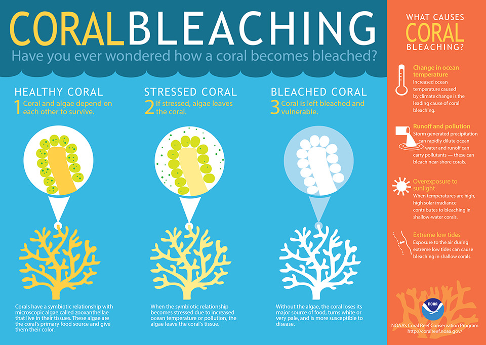

Ocean acidification slows down the growth of coral. Ocean absorbs one-third of the atmosphere’s excess carbon dioxide. This makes the ocean acidic which reacts with limestone skeleton of corals and dissolves them. In order for a coral reef to grow, it must produce limestone at a rate that is faster than the reef is being eroded. This slows down the growth.
Q.23) Four of the world’s biodiversity hotspots fall in India. Which of the following factors are considered for a place to become a biodiversity hotspot?a) Number of total species
b) Number of unique species
c) Number of species at risk
d) All of the above
b) Number of unique species
c) Number of species at risk
d) All of the above
Ans- [D]
Explanation:A biodiversity hotspot is a biogeographic region with significant levels of biodiversity that is under threat from humans. To qualify as a biodiversity hotspot, a region must meet two strict criteria: it must contain at least 0.5% or 1,500 species of vascular plants as endemics, and it has to have lost at least 70% of its primary vegetation.
Endemic species are species which are unique to a defined geographic location.
Q.24) The physical world map shows that there is a certain definite pattern to the location of the world’s deserts. Consider the following statements in this context-
- Almost all deserts lie within 15 and 30 degrees north and south of the equator
- Almost all deserts lie in the trade wind belt on the western parts of the continent
Which of the above statements is/are correct?
a) 1 only
b) 2 only
c) Both 1 and 2
d) Neither 1 nor 2
a) 1 only
b) 2 only
c) Both 1 and 2
d) Neither 1 nor 2
Ans-[C]
Explanation: Statement 1 is correct. Majority of the world deserts are found along the Tropic of Cancer, between 15 and 30 degrees north of the Equator, or along the Tropic of Capricorn, between 15 and 30 degrees south of the Equator.
Statement 2 is also correct. These desert lie in the trade wind belt on the western parts of the continents. Here trade winds are off-shore and they are influenced by cold currents which produce a ‘desiccating effect’. This causes very less rain.
Q.25) Secondary circulation in the atmosphere consists of
- Polar easterlies
- Temperate cyclones
- Mountain wind
- Monsoon
- Sea breeze
Select the correct answer using the codes given below:
a) 1 and 4 only
b) 2 and 4 only
c) 1, 2 and 4 only
d) 3 and 5 only
a) 1 and 4 only
b) 2 and 4 only
c) 1, 2 and 4 only
d) 3 and 5 only
Ans- [B]
Explanation:Atmospheric circulation is categorized as
- Primary circulation – General, worldwide patterns, planetary winds eg westerlies winds
- Secondary circulation- Regional circulation patterns (e.g. monsoons that are limited to South and South-east Asia)
- Tertiary circulation – Local winds for ex- Loo, Sea breeze, land breeze, Mountain winds and Valley breezes are known as Tertitary circulation.
Polar easterlies is an example of global pattern or primary circulation.
Cyclone, anticyclones, monsoon are example of regional circulation pattern.
Hence ans is 2 and 4 only
Q.26) Three major hills of the Purvanchal are-
- Naga hills
- Patkai hills
- Lushai hills
Arrange these hills in the right order from north to south using the codes given below:
a) 1, 3, 2
b) 2, 1, 3
c) 3, 1, 2
d) 2, 3, 1
a) 1, 3, 2
b) 2, 1, 3
c) 3, 1, 2
d) 2, 3, 1
Ans- [B]
Explanation- Mizo hills were formerly known as Lushai hills. See Atlas.
Q.27) Punjab and Haryana exploit almost 85% of groundwater for irrigation. The reason is –
- Low surface water availability
- Impact of green revolution
- Change in cropping pattern with an increased preference of rice
Select the correct answer using the codes given below:
a) 1 only
b) 2 only
c) 3 only
d) 1, 2 and 3
a) 1 only
b) 2 only
c) 3 only
d) 1, 2 and 3
Ans-[D]
Explanation- Statement 2 is obvious reason. Due to the green revolution and change in the cropping diversification in these states towards rice has unprecedentedly exploited groundwater resources.
No comments :
Post a Comment