GEOGRAPHY STRATEGY
1. Weightage given since 2011
2. Recent Trend
3. Clarity of Concepts
4. Indian Geography
2. Recent Trend
3. Clarity of Concepts
4. Indian Geography
GEOGRAPHY (Indian and World Geography-Physical, Social, Economic)
‘Geography is the study of man, his environment and interaction between the two’. This definition of geography tells you about the comprehensive nature of Geography and its vastness.
Geography has ‘overlapping’ topics which covers Environment, Economics (Human geography- Demograpy) and Current Events. One should always have an ATLAS while studying geography. It gives you more insights, makes your reading more meaningful and enjoyable.
Recent Trend
Weightage Given
As per the recent trend, atleast 15-20% weightage is given to Geography. Prima facie it may seem that weightage given to Geography has declined as compared to the pre 2011 times. But that is not the case. We would illustrate with an example:
| With reference to micro-irrigation, which of the following statements is/are correct? (2011)
1. Fertilizer/nutrient loss can be reduced
2. It is the only means of irrigation in dry land farming. 3. In some areas of farming, receding of ground water table can be checked.
Select the correct answer using the codes given below:
(a.) 1 only
(b.) 2 and 3 only (c.) 1 and 3 only (d.) 1, 2 and 3
Solution (c)
|
This question, though basically forms part of Current Events section, has a direct correlation with Geography.
| Which of the following can be threats to the biodiversity of a geographical area?(2012)
1. Global warming
2. Fragmentation of habitat 3.Invasion of alien species 4. Promotion of vegetarianism
Select the correct answer using the codes given below :
(a) 1, 2 and 3 only
(b) 2 and 3 only (c) 1 and 4 only (d) 1, 2, 3 and 4
Solution (a)
|
This question, though basically forms part of ‘Environment’ section, it has a direct correlation with Indian Geography.
Due to the overlapping nature of questions, and increase in weightage given to Environment, Geography becomes even more important. Many of these questions can be answered, when basic concepts in Geography is clear.
Clarity of Concepts
While studying Geography, clarity of concepts and it should be substantiated with appropriate facts. Everybody (from your seniors, people who have cleared the exam, friends, fellow aspirants, even the dabbawala’s, house-brokers in delhi  ) keep talking about this clarity of concepts. But would not have explained you what does it really mean
) keep talking about this clarity of concepts. But would not have explained you what does it really mean
So the next question is, what do you understand by ‘Clarity of concepts’?
We would illustrate this with an example:
| The Narmada river flows to the west, while most other large peninsular rivers flow to the east. Why?(2013)
1. It occupies a linear rift valley.
2. It flows between the Vindhyas and the Satpuras. 3. The land slopes to the west from Central India.
Select the correct answer using the codes given below.
(a) 1 only
(b) 2 and 3 (c) 1 and 3 (d) None
Solution (a)
|
Concept: Why does ‘narmada river’ is a West flowing river and not East?
Fact: Narmada river is a West flowing river.
Think & Learn: (This is for you to ponder over)
- Which are the other west flowing rivers?
- Why do some rivers flow West, while majority flows in the East direction?
- Why do rivers flowing in the East direction form Deltas?
- A general awareness on which ‘States’ they flow and ‘Hydro-electrical Projects’ and ‘Dams’ constructed across these rivers.
By now, from the above illustrations’ you would have understood the following aspects:
- Importance of Geography
- Clarity of Concepts
- Significance of facts
- Level of Difficulty of Questions
Now, let us get into the detail strategy of Geography
GEOGRAPHY is divided into two parts– Indian Geography and World Geography.
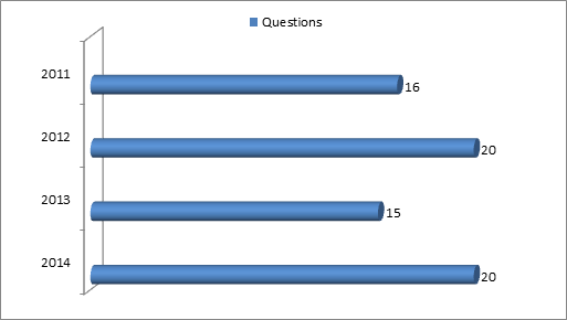
Weightage given to Indian Geography (since 2011)
| YEAR | MARKS |
| 2011 | 12 |
| 2012 | 18 |
| 2013 | 11 |
| 2014 | 16 |
More importance should be given to Indian Geography, which accounts for 80% of Geography Prelims Questions.
How to approach Indian Geography?
Physiography:
India’s physiography is so diverse that it can be divided into:
- The Himalayas- The Greater Himalayas(Himadri), Lesser Himalayas(Himachal), Sub-Himalayas (Siwaliks)
- Peninsular Plateau and Peninsular Mountains
- The North Plains and the Coastal plains
- Indian Desert
- Islands
Focus:
- Characteristics – Example: Himalayas are young, weak, flexible
- How were they formed? Example: The peninsula block was formed by various vertical movements and block faulting
- Climate and Rainfall in these regions
- Vegetation or Type of Forests found
- Soil along the slopes
- Biodiversity in the region
Example (2012 Prelims Questions Paper):·
| When you travel in Himalayas, you will see the following :
1. Deep gorges
2. U-turn river courses 3. Parallel mountain ranges 4. Steep gradients causing land-sliding
Which of the above can be said to be the evidences for Himalayas being young fold mountains?
(a) 1 and 2 only
(b) 1, 2 and 4 only (c) 3 and 4 only (d) 1, 2, 3 and 4
Solution (d)
|
River System in India:
- Indian River System can be broadly classified into 2 Major systems
- Himalayas River system consist of -Indus, Ganga, Brahamaputra,
- Peninsular River Systems
Focus:
- Evolution of the drainage (river) system
- Characteristics of the River system. Example: Peninsular river system is older than the Himalayan river system. They are non-perennial rivers.
- The states they flow through
- Comparison between the Himalayas and the Peninsular river system
- Hydro-Power projects, other Power plants and Major Dams built on these rivers. Example:Salal project on River Chenab
- West flowing rivers in India. Why do these rivers flow West, while majority rivers flow in the East direction?
- Why do east flowing rivers form deltas?
Example (2011 Prelims Questions Paper)
The Brahmaputra, Irrawady and Mekong rivers originate in Tibet and flow through narrow and parallel mountain ranges in their upper reaches. Of these rivers, Brahmaputra makes a “U” turn in its course to flow into India. This “U” turn is due to (2011)
(a.) Uplift of folded Himalayan series
(b.) Syntaxial bending of geologically young Himalayas
(c.) Geo-tectonic disturbance in the tertiary folded mountain chains
(d.) Both (a) and (b) above
Solution (b)
|
Minerals
Focus
- Major areas where they are found
- Characteristics of the minerals
- It’s Uses and Environmental impact.
Example: Coal occurs mainly in Gondwana region. It is used in power generation, but since it’s a fossil fuel it leads to release of CO2 (a major greenhouse gas)
Example (2013 Prelims Questions Paper): ·
| Consider the following statements: (2013)
1. Natural gas occurs in the Gondwana beds.
2. Mica occurs in abundance in Kodarma. 3. Dharwars are famous for petroleum.
Which of the statements given above is/are correct?
(a) 1 and 2
(b) 2 only (c) 2 and 3 (d) None
Solution (b)
|
Example (2014 Prelims Questions Paper):
| With reference to two non-conventional energy sources called ‘coal bed methane’ and ‘shale gas’, consider the following ‘statements: 1. Coal bed methane is the pure methane gas extracted from coal seams, while shale gas is a mixture of propane and butane only that can be extracted from fine-grained sedimentary rocks. 2. In India abundant coal bed methane sources exist, but so far no shale gas sources have been found.Which of the statements given above is/are correct?A. 1 only B. 2 only C. Both 1 and 2 D. Neither 1 nor 2
Solution (d)
|
Climate
Note: Before studying about Monsoons, go through the Climate topic under World Geography for Basic understanding on Climate and Weather.
Focus
- Factors determining the Climate of India
- Indian Monsoon
- It’s nature/characteristics, significance and impact
- Upper Air circulation- Jet streams, Westerlies
- Cyclones – tropical and temperate
- El-Nino, La-Nino (More Emphasis should be given)
- How is it developed?
- How does this effect Indian climate and vegetation
- Related concepts like upwelling and its advantages
Example (2011 Prelims Questions Paper):·
| La Nina is suspected to have caused recent floods in Australia. How is La Nina different from El Nino?
(a.) La Nina is characterised by unusually cold ocean temperature in equatorial Indian Ocean whereas El Nino is characterised by unusually warm ocean temperature in the equatorial Pacific Ocean.
2. El Nino has adverse effect on south-west monsoon of India, but La Nina has no effect on monsoon climate.
Which of the statements given above is/are correct?
(a.) 1 only
(b.) 2 only
(c.) Both 1 and 2
(d.) Neither 1 nor 2
Solution (d)
Example (2012 Prelims Questions Paper):·
|
Soil:
Focus:
- Soils in India –Alluvial, Black, Red, Laterite
- Its location (availability)
- Characteristics
- Crops grown.
- Example: Laterite soil contains iron oxide which imparts red colour to the soil. Its poor in humus and nitrogen due to heavy leaching. It’s found in Western Coastal plain
- Factors which control the formation of soil
- Soil Erosion – Sheet erosion, gully erosion etc.- causes
- Impact of salinization, alka , acidification of soil
- Soil Conservation methods – crop rotation, Contour farming, Terracing, cover crops, conservation tillage and planted windbreaks
Example (2013 Prelims Questions Paper): ·
| Contour bunding is a method of soil conservation used in:
(a) desert margins, liable to strong wind action
(b) low flat plains, close to stream courses, liable to flooding
(c) scrublands, liable to spread of weed growth
(d) None of the above
Solution:
|
| Which of the following statements regarding laterite soils of India are correct?
1. They are generally red in colour.
2. They are rich in nitrogen and potash.
3. They are well-developed in Rajasthan and UP.
4. Tapioca and cashew nuts grow well on these soils.
Select the correct answer using the codes given below.
(a) 1, 2 and 3
(b) 2, 3 and 4
(c) 1 and 4
(d) 2 and 3 only
Solution (c)
|
Agriculture:
Focus:
- Cropping Pattern: Example: Rice, Wheat, Pulses, Sugarcane, Millets, Coffee, Tea etc.
- Where(states) are they are grown?
- Climatic conditions suitable for their growth
- Classification of crops- Kharif crops, Rabi and Zaid crops with examples.
- Irrigation – New irrigation methods like Micro-irrigation, Drip-irrigation their usage, advantages and disadvantages
- Farming – Shifting cultivation, Terrace cultivation, Crop Rotation, Mixed and Multiple farming – where are these methods practiced; advantages and disadvantages.
Example (2011 Prelims Questions Paper):
|
A state in India has the following characteristics:
1. Its northern part is arid and semi-arid.
2. Its central part produces cotton.
3. Cultivation of cash crops is predominant over food crops.
Which one of the following states has all of the above characteristics?
(a.) Andhra Pradesh
(b.) Gujarat
(c.) Karnataka
(d.) Tamil Nadu
Solution (b)
|
| With reference to micro-irrigation, which of the following statements is/are correct?
1. Fertilizer/nutrient loss can be reduced.
2. It is the only means of irrigation in dry land farming.
3. In some areas of farming, receding of ground water table can be checked.
Select the correct answer using the codes given below:
(a.) 1 only
(b.) 2 and 3 only
(c.) 1 and 3 only
(d.) 1, 2 and 3
Solution (c)
|
Example (2013 Prelims Questions Paper):·
| Consider the following crops
1.Cotton
2. Groundnut
3. Rice
4.Wheat
Which of these are Kharif crops?
(a) 1 and 4
(b) 2 and 3 only
(c) 1, 2 and 3
(d) 2, 3 and 4
Solution (c)
|
Forests (or Natural Vegetation)
Focus:
- Tropical Evergreen forests, Deciduous, Hill forests Thorn, Littoral and Swamp forests
- Temperature, Rainfall conducive for the growth of these Forests
- Regions they occur/grow
- Types of trees grown (general awareness)
- Economic utilities of these forests
Example: Deciduous Forests found in areas of rainfall 150-200 cm;They are found majorly in Peninsular India; Trees like teak, sal, sandalwood, rosewood grow here. They are less dense unlike evergreen forests and are a source of good quality timber.
Example (2011 Prelims Questions Paper):·
|
Among the following States, which one has the most suitable climatic conditions for the cultivation of a large variety of orchids with minimum cost of production, and can develop an export oriented industry in this field?
(a.) Andhra Pradesh
(b.) Arunachal Pradesh
(c.) Madhya Pradesh
(d.)Uttar Pradesh
Solution (b)
| |
|
Example (2013 Prelims Questions Paper):
Which of the following is/are unique characteristic/characteristics of equatorial forests?
1. Presence of tall, closely set trees with crowns forming a continuous canopy
2. Coexistence of a large number of species
3. Presence of numerous varieties of epiphytes
Select the correct answer using the code given below:
(a) 1 only
(b) 2 and 3 only
(c) 1 and 3 only
(d)1, 2 and 3
Solution (d)
| |
Human Geography
Focus
- Major Tribal groups and States they belong to; their Skills; Festivals they celebrate.
- Demographic dividend
Example (2013 Prelims Questions Paper):
| Consider the following pairs :
Tribe State
1. Limboo (Limbu) : Sikkim
2. Karbi : Himachal Pradesh
3. Dongaria : Odisha
4. Bonda : Tamil Nadu
Which of the above pairs are correctly matched?
(a) 1 and 3 only
(b) 2 and 4 only
(c) 1, 3 and 4 only
(d) 1, 2, 3 and 4
Solution (a)
|
Example (2014 Prelims Questions Paper)
| Every year, a month long ecologically important campaign/festival is held during which certain communities/ tribes plant saplings of fruit-bearing trees. Which of the following are such communities/tribes?
A. Bhutia and Lepcha
B. Gond and Korku
C. lrula and Toda
D. Sahariya and Agariya
Solution (b)
|
Wildlife and Conservation of flora and fauna
This topic overlaps with Environment
Focus
- Bird Sanctuaries, National Park, Wildlife Sanctuary, Tiger Reserves, Biosphere Reserves, Wetlands
- Be aware of their location, near-by important places on the map
- Differences among the three Protected areas- National Park, Wildlife Sanctuary, Biosphere Reserves
- Endangered Species, Vulnerable and Extinct species
- Protected Areas and Important Species found
Example (2011 Prelims Questions Paper):
Two important rivers — one with its source in Jharkhand (and known by a different name in Odisha), and another, with its source in Odisha — merge at a place only a short distance from the coast of Bay of Bengal before flowing into the sea. This is an important site of wildlife and biodiversity and a protected area. Which one of the following could be this?
(a.) Bhitarkanika
(b.) Chandipur-on-sea
(c.) Gopalpur-on-sea
(d.) Simlipal
Solution (a)
|
Example (2014 Prelims Questions Paper):
| Consider the following pairs
1. Dampa Tiger Reserve : Mizoram
2. Gumti Wildlife Sanctuary : Sikkim
3. Saramati Peak : Nagaland
Which of the above pairs is /are correctly matched?
A. 1 only
B. 2 and 3 only
C. 1 and 3 only
D. 1, 2 and 3
Solution (c)
|
Note: For better understanding and easier way to remember refer Page No. 35 ‘India- Forest and Wildlife’ in the ‘The Orient BlackSwan School Atlas’. The wildlife section is factual and difficult to remember, especially questions like –Which of the following belong to vulnerable category or where is this particular endangered species is found?
Luck too plays its part here. So, some of them skip this section. But you can definitely be smart here, by focusing on the important Conservation sites and important Species found and the States they are located; the three categories of Species like Critically- Endangered, Endangered and Vulnerable.
-----------------------
WORLD GEOGRAPHY
How to Approach World Geography
The major part of Physical Geography, various concepts and phenomena’s related to it come under World geography. Hence the topics under World Geography might seem to be vast. But covering these topics will not only help you in strengthening your conceptual understanding of Geography but also in Environment section (which forms a major part in UPSC prelims examination)
The Earth and the Universe
Focus:
- The Solar system; differences between meteors, asteroids, comets and region where they are found
- Motion of the Earth – Rotation and Revolution – it’s impact on Day and Night;
- Inclination of the Earth’s Axis – it’s effect on seasons
- Latitude and Longitude
- Important Parallels and Meridians – the countries they pass through
- General understanding of Solar Eclipse, Lunar Eclipse and Tides and their significance
- Earth’s crust
- The Structure of the Earth
- Classification of Rocks – Igneous, Sedimentary, Metamorphic with examples.
Example (2011 Prelims Questions Paper):
| What is die difference between asteroids and comets?
1. Asteroids are small rocky planetoids, while comets are formed of frozen gases held together by rocky and metallic material.
2. Asteroids are found mostly between the orbits of Jupiter and Mars, while comets are found mostly between Venus and Mercury.
3. Comets show a perceptible glowing tail, while asteroids do not.
Which of the statements given above is/are correct?
(a.) 1 and 2 only
(b.) 1 and 3 only
(c.) 3 only
(d.) 1, 2 and 3
Solution (b)
|
Example (2012 Prelims Questions Paper):
| Consider the following factors:
1. Rotation of the Earth
2. Air pressure and wind
3. Density of ocean water
4. Revolution of the Earth
Which of the above factors influence the ocean currents?
(a) 1 and 2 only
(b) 1, 2 and 3
(c) 1 and 4
(d) 2, 3 and 4
Solution (b)
|
Landforms:
Focus
- A general idea about Continental Drift Theory, Plate Tectonics Theory, Sea Floor Spreading
- Geomorphic process
- Exogenic and Endogenic process, geomorphic agents – its impact.
- Volcanoes – why and how are they formed?
- Weathering and its significance
- Mass Movements – creep, avalanche, landslides
- Erosion and Deposits.
- Basic ideas on other landforms like deltas, valleys, meanders, alluvial fans, caves, glaciers, cliffs, terraces, dunes
- Earth’s movements like folding, faulting, warping and its impact on Landforms
- Earthquakes – their origin, why and how are they formed, Earthquake Waves like P waves, S Waves, L Waves
- Geographical features – Atlas mountains, Highlands and the regions they are found in; Desert regions across the world
Note: You can expect match the following questions from ‘World Geographic features/landforms’
Example (2013 Prelims Questions Paper):
| Which one of the following pairs is correctly matched?
Geographical Feature Region
(a) Abyssinian Plateau : Arabia
(b) AtlasMountains : North-Western Africa
(c) Guiana Highlands : South-Western Africa
(d) OkavangoBasin : Patagonia
Solution (b)
|
Example (2014 Prelims Questions Paper):
| Which of the following phenomena might have influenced the evolution of organisms?
1. Continental drift
2. Glacial cycles
Select the correct answer using the code given below.
A. 1 only
B. 2 only
C. Both 1 and 2
D. Neither 1 nor 2.
Solution (c)
|
Atmosphere: (An important topic from Prelims point of view)
Focus:
- Composition and Structure of Atmosphere various layers of atmosphere significance of each layer
- Important gases in the atmosphere, its significance and role in protecting human life
- Example: ozone in the stratosphere prevents harmful ultra-violet radiations from reaching the earth and thereby protecting the humans from skin cancer etc.
- Heating and Cooling of Atmosphere; Factors controlling temperature distribution
- Heat Budget (Incoming and outgoing radiation)
- Greenhouse Effect and Global Warming- Ozone layer, Ozone hole.
- Temperature Zones on the globe- Tropical, Temperate, Frigid ; characteristics of these zones
- Global Pressure Belts- Low Pressure, High Pressure, Doldrums, Horse Latitudes
- Concepts like Temperature Inversion, Albedo.
Example (2011 Prelims Questions Paper):
| A layer in the Earth’s atmosphere called Ionosphere facilitates radio communication. Why?
1. The presence of ozone causes the reflection of radio waves to Earth.
2. Radio waves have a very long wavelength.
Which of the statements given above is/are correct?
(a.) 1 only
(b.) 2 only
(c.) Both 1 and 2
(d.) Neither 1 nor 2
Solution (d)
|
Example (2012 Prelims Questions Paper):
| Normally, the temperature decreases with the increase in height from the Earth’s surface, because
1. the atmosphere can be heated upwards only from the Earth’s surface
2. there is more moisture in the upper atmosphere
3. the air is less dense in the upper atmosphere
Select the correct answer using the codes given below :
(a) 1 only
(b) 2 and 3 only
(c) 1 and 3 only
(d) 1, 2 and 3
Solution (a)
|
Wind System
Focus:
- Factors affecting the velocity and direction of the Wind. Example: How does Coriollis force affects the direction of wind?
- Planetary Winds, shifting of Planetary wind belts and their climatic influences in the Northern and Southern Hemisphere, Inter-tropical and Convergence Zone.
- Seasonal and local Winds – Monsoons, Land and Sea breezes, Anabatic and Katabatic winds, Blizzards, Chinook
- Mountain and Valley winds
- Fronts – Warm and Cold front
- Upper Air circulation- Jet streams, Westerlies
- Phenomena’s like cyclones, anti-cyclones, thunderstorms, tornadoes.
- Cyclones – Tropical and Temperate (More Emphasis should be given)
- How are they developed or where do they originate?
- Characteristic’s of these cyclones
- Difference between the two
- It’s impact on the region
Example (2011 Prelims Questions Paper):·
| The formation of ozone hole in the Antarctic region has been a cause of concern. What could be the reason for the formation of this hole? (2011)
(a.) Presence of prominent tropo-spheric turbulence; and inflow of chlorofluorocarbons
(b.) Presence of prominent polar front and stratospheric’ clouds; and inflow of chlorofluorocarbons
(c.) Absence of polar front and stratospheric clouds; and inflow of methane and chlorofluorocarbons
(d.) Increased temperature at polar region due to global warming
Solution (b)
|
Example (2013 Prelims Questions Paper):
| During a thunderstorm, the thunder in the skies is produced by the: (2013)
1. meeting of cumulonimbus clouds in the sky
2. lightning that separates the nimbus clouds
3. violent upward movement of air and water particles
Select the correct answer using the codes given below.
(a) 1 only
(b) 2 and 3
(C) 1 and 3
(d) None of the above produces the thunder
Solution (d)
|
Clouds and Precipitation
Focus:
- Classification of Clouds
- Condensations and its forms- Dew, Frost, Fog, Smog, Mist and Haze; How are they different from each other?
- Precipitation
- Forms of Precipitation – Rainfall, Sleet, Snowfall, Hail
- Mechanism of Condensation and Precipitation – adiabatic cooling
- Types of Precipitation – Convectional, Orographic, Cyclonic, Frontal precipitation.
Hydrosphere:
Focus:
- A general idea about configuration of Ocean Floor – Continental Shelf, Slope, Rise, Abyssal Plan, Trenches.
- Straits and Isthmuses- differences between them; Locate the famous Straits and Isthmuses on Atlas. Example: Strait of Gibraltar, Isthmus of Panama.
- Fresh water found on the Earth’s surface. Ice caps, Glaciers and ground Water, Lakes, atmosphere
- Ocean Currents (More Emphasis should be given)
- Factors influencing the Movement of the Ocean Currents- Planetary Winds, Temperatures, Salinity, Earth’s Rotation, Land mass
- Types- Warm and Cold Currents
- What are Warm and Cold Currents, why are they called so?
- Characteristics of the Currents
- Identify the Warm and Cold Currents and their direction of flow in Northern and Southern Hemisphere. Example: Peru Cold current, in the Southern Hemisphere flows in the Anti-Clockwise direction
- How do these currents influence the climate and vegetation across the world?
- Benefits of these currents, Example: Confluence of Warm and Cold currents is region rich in fisheries. Disadvantages – Example: They make navigation difficult for the sailors
Example (2013 Prelims Questions Paper):
|
On the planet earth, most of the freshwater exists as ice caps and glaciers. Out of the remaining freshwater, the largest proportion
(a) is found in atmosphere as moisture and clouds
(b) is found in freshwater lakes and rivers
(c) exists as groundwater
(d) exists as soil moisture
Solution (c)
The most important fishing grounds of the world are found in the regions where:(2013)
(a) warm and cold atmospheric currents meet
(b) rivers drain out large amounts of fresh water into the sea
(c) warm and cold oceanic currents meet
(d) continental shelf is undulating
Solution (c)
|
Different Climatic types
Focus:
- Have a basic idea about major Climatic Types – Tropical, Desert, Mediterranean, Taiga, Arctic (or Polar type)
- Distribution or regions found (a general awareness)
- Climate – temperature, rainfall (not exact numbers, just the range is enough)
- Natural Vegetation, Forests:
- Tropical (Forests, Grasslands, Deserts)
- Mediterranean
- Temperate ( Forests, Grasslands, Deserts)
- Polar Tundra
- Importance of the region and other activities carried out
- Example: The Arctic or Polar Climate- they are found mainly in the north of the Arctic circle in the Northern Hemisphere. Temperature- ranges from 10 C to -37 C, Winters are long and very severe whereas summers are cool and brief. Precipitation is in the form of snow. Tundra Vegetation. It has gained importance due to discovery of minerals.
- How do all these phenomenon influence Indian climate and vegetation
- For better understanding refer these pages in the ‘The Orient BlackSwan School Atlas’
- Atlas: Page No. 84 ‘Natural Vegetation’ and Page No. 85 ‘Climatic Regions’
Note: These pointers might be boring or difficult to remember. But using an Atlas, while studying these aspects of Geography, will make your preparation process enjoyable. You don’t believe us. Then, pick up an Atlas and experience it yourself J
Note: Though Topics like Ecosystems, Biomes, Biogeochemical cycles (Carbon, Nitrogen, Oxygen), Biodiversity and Conservation come under Geography they are covered under Environment Section
Example (2011 Prelims Questions Paper):
| What could be the main reason/reasons for the formation of African and Eurasian desert belt?
1. It is located in the sub-tropical high pressure cells.
2. It is under the influence of warm ocean currents.
Which of the statements given above is/are correct in this context?
(a.) 1 only
(b.) 2 only
(c.) Both 1 and 2
(d.) Neither 1 nor 2
Solution (a)
|
Example (2012 Prelims Questions Paper):
| Which one of the following is the characteristic climate of the Tropical Savannah Region? (2012)
(a) Rainfall throughout the year
(b) Rainfall in winter only
(c) An extremely short dry season
(d) A definite dry and wet season
Solution (d)
|
Example (2013 Prelims Questions Paper):
“Climate is extreme, rainfall is scanty and the people used to be nomadic herders.” The above statement best describes which of the following regions?
(a) African Savannah
(b) Central Asian Steppe
(c) North American Prairie
(d) Siberian Tundra
Solution (b)
|
Last but not the Least – Map-based questions have been frequently asked in UPSC prelims
Check out a few of them (from 2014 Question paper alone, 6 Questions had come). That is why, in the beginning itself, we had advised you to always keep an Atlas by your side while preparing for Geography
Though UPSC keeps changing its pattern of questions every year, atleast one can accept minimum 2 questions from Maps alone.
So, the next question would be- how to study/read Maps?
Studying maps alone is not advised and it is impossibleJ . While studying Geography or when you are reading Daily Newspaper, supplement it with an Atlas. When you read about a ‘place’ that is in news, look out for it in the Atlas; and also be aware of the nearby places.
Map-based Questions
Few Examples from 2014 Prelims Questions Paper
| Which one of the following pairs of islands is separated from each other by the ‘Ten Degree Channel’?
A. Andaman and Nicobar
B. Nicobar and Sumatra
C. Maldives and Lakshadweep
D. Sumatra and Java
Solution (a)
|
|
Turkey is located between
A. Black Sea and Caspian Sea
B. Black Sea and Mediterranean Sea
C. Gulf of Suez and Mediterranean Sea
D. Gulf of Aqaba and Dead Sea
Solution (b)
What is the correct sequence of occurrence of the following cities in South-East Asia as one proceeds from south to north?
1.Bangkok
2.Hanoi
3.Jakarta
4.Singapore
Select the correct answer using the code given below.
A. 4-2-1-3
B. 3-2-4-1
C. 3-4-1-2
D. 4-3-2-1
Solution (c)
Consider the following pairs
Region often in news Country
1. Chechnya Russian Federation
2. Darfur Mali
3. Swat Valley Iraq
Which of the above pairs is/are correctly matched?
a. 1 only
b. 2 and 3 only
c. 1 and 3 only
d. 1, 2 and 3
Solution (a)
Consider the following rivers:
1. Barak
2. Lohit
3. Subansiri
Which of the above flows / flow through Arunachal Pradesh?
A. 1 only
B. 2 and 3 only
C. 1 and 3 only
D. 1, 2 and 3
Solution (b)
| |
| Consider these pairs
1. Cardamom Hills Coromandel Coast
2. Kaimur Hills Konkan Coast
3. Mahadeo Hills Central India
4. Mikir Hills North-East India
Which of the above pairs are correctly matched?
A. 1 and 2
B. 2 and 3
C. 3 and 4
D. 2 and 4
Solution (c)
| |
No comments:
Post a Comment